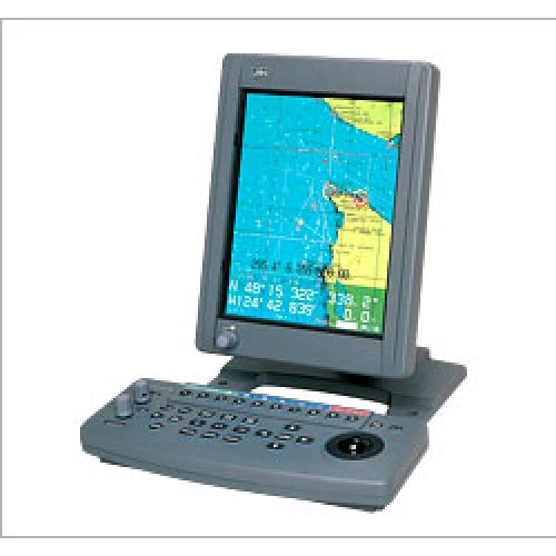
JRC Marine GPS Color Plotter JLZ 700
GPS Chartplotter System: JRC Marine GPS Color Plotter JLZ 700
JRC Marine GPS Color Plotter JLZ 700
Navigational and operational information can be seen clearly on the same screen.
♦Detailed coastline information with geographical names
The detailed coastline information includes landmarks such as geographic names, allowing easy check on own ship's current position and fishing grounds.
♦Display of various types of information
Various types of information including the topographic features of sea bottoms, user data on fishing grounds and navigational information can be displayed using JRC's unique marks, symbols and lines such as for example, for a fish-breeding reef, sunken ship, sea bottom topology or prohibited district.
♦Flexible display operation
The display can be enlarged, scaled or scrolled easily at high speed. While watching the coastlines and fishing ground data, you can search for a target fishing ground swiftly.
♦Easy entry by trackball
The cursor operation using a trackball allows any mark or symbol to be entered on the display in an easy way.
♦JRC DGPS receiver connectable
A JRC differential GPS receiver that is optionally available can be connected directly to the JLZ-700 plotter to ensure the positioning with a high accuracy of several meters.
♦C-MAP NT+ is available
♦Three component configuration:Processor,Keyboard and Display
♦10.4" Color LCD (640x480 VGA)display meets IPX5 waterproofing, vibration specifications IEC60945
♦Display unit monitor swivels and tilts for easy viewing with variable illumination setting for personal preference
♦Second display capability with one processor using optional RGB Video output (CAD-239)
 |
 |
 |
||
| Course up mode | C-MAP card indication | Water temperature a track indication |
| Display | 10.4 inch high-luminance TFT color LCD | |
| Display method | Mercator projection (up to lat. 85°) (in equidistant presentation) |
|
| Chart scale | 1/1,000 to 1/10,000,000 variable continuously or in 10 steps | |
| Track display | Display color | 7 colors |
| Plotting intervals | 1, 3, 5, 10 or 30 sec., 1, 5, 30 or 60 min., or Settable to a distance of 0.1, 0.5, 1, 3, 5, 10 miles and Off. | |
| Memory capacity | 20,000 points (including marks) | |
| Marks | Display color | 7 colors |
| Memory capacity | 20,000 points (including trail) | |
| Mark types | 5 types (selectable from 13 types) | |
| Event marks | Display color | 7 colors |
| Memory capacity | Included in the mark memory | |
| Mark types | 3 types (selectable from 9 types) | |
| Waypoint marks | 999 points | |
| Chart data | CMAP-NT and NT + card (option) | |
| External memory | Memory card with a capacity of 100,000 points (option) | |
| Cursor | Trackball operation | |
| Data display | Own ship's current position, scale, bearing / range / time to destination, own ship's course / speed, cursor position and time | |
| Data output | NMEA 0183 and JRC format | |
| Other features | Screen width display Instant plot storing DGPS/GPS receiver, DGPS212/GPS112 connectable Loran A/C time difference display Decca LOP display (with correction) Route planning External event input External buzzer output (relay contact) |
|
| Power supply | 12/24/32 VDC (10.8 to 42 VDC) 40W (MAX) | |
| Operating temperature | -15deg.C to +55deg.C | |
| Options | GPS receiver GPS112 DGPS receiver DGPS212 Video output unit CAD-239 |
|

 |
| Mass : 2.8kg |
 |
| Mass : 1kg |
 |
| Mass : 3.5kg |

